The politics of the Old Wagon Cave campground over the past 5 decades shows a pattern of increasing restrictions on camping and other free use by the locals here. The Feds, along with their community organizers, have progressively shrunk the areas where large numbers of ordinary people can drive and enjoy the outdoors in this section of Los Padres National Forest. This shrinkage has followed four paths: (1) encroachment by the Ventana Wilderness, (2) erasure of roads on maps, (3) potential encroachment by a so-called Milpitas SIA (special interest area), and (4) other restrictions on camping and driving. We’re not even counting the fact that an army map shows the Old Wagon Cave campground here while the U.S. Forest Service maps do not.
1. Ventana Wilderness encroachment
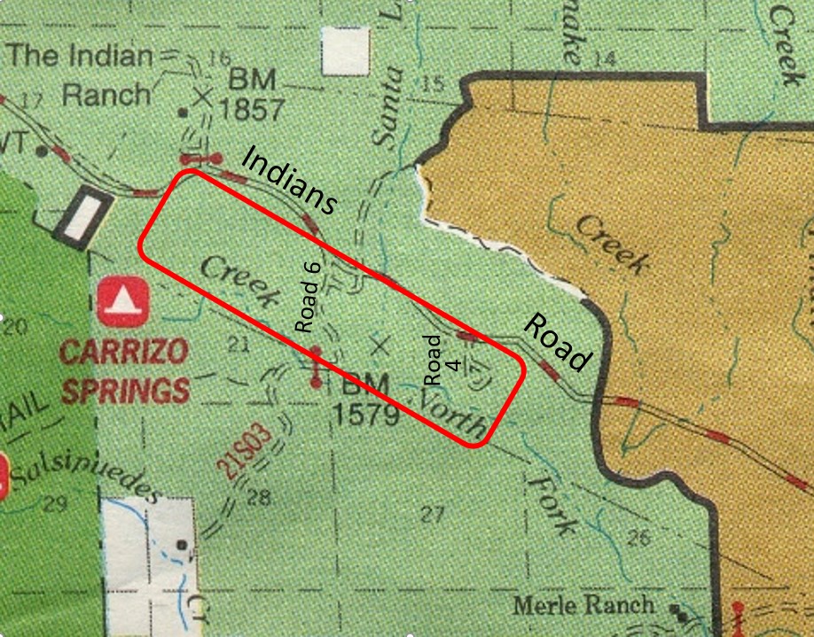
The Ventana Wilderness was established in 1969. It then measured about 160,000 acres. In 1978, the wilderness was doubled in size. The 1978 map, below (Map 1), shows the wilderness barely encroaching into the southwest corner of the area. Everywhere else here is accessible to motor vehicles.

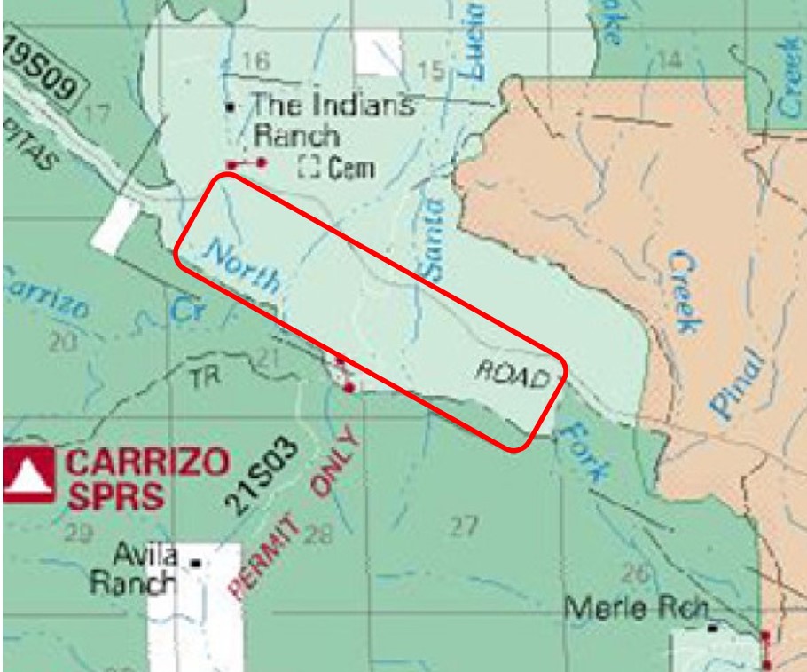
The 1996 U.S. Forest Service map, below (Map 2), shows the Ventana Wilderness, as in the 1978 map (Map 1), starting to encroach closer toward the campground area from the southwest. The wilderness is the dark-green area on the left.
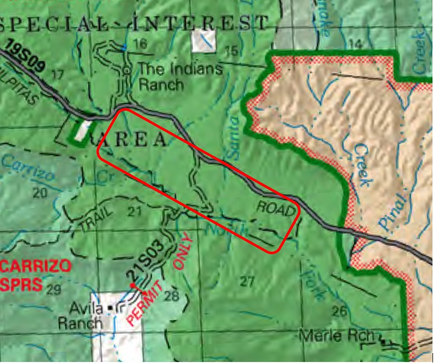
The 2005 U.S. Forest Service map below (Map 3), shows the Ventana Wilderness encroaching around the campground area. The wilderness is now the medium-green area covering most of the area. The light-green area is now what’s left of land that cars can drive on.
Why can’t “they” leave well enough alone? Why don’t the wilderness boundaries stay where they are?
Simple. Politics. Politics, the word, is derived from the Greek root words poly, meaning many, and tics, meaning blood-sucking parasites. Local congressional representatives serve a few terms in Congress and have limited lifespans, but they seek fame and glory and to have their names preserved for posterity. And they seek higher office. If they can say, “I co-authored a bill to expand the Such-and-such Wilderness” or “I authored a bill to designate a semistagnant stretch of the San Antonio River down to Merle Ranch a Wild and Scenic River,”1 then they can say to voters, “Ooh, lookie, my environmental left-wing bona-fides are oh so strong, please elect me Lieutenant Governor,” and 52% of voters (91% of low-information voters) will fall for the ruse.
2. “Nothing to see here, folks, move along”
The Feds are eager to obscure roads, which cars can drive on and bring lots of ordinary people on, but not trails, which only a few backpackers can access.
Note how in the 2005 map (Map 3, above), the paved road is now only a faint gray line and how only one or two unpaved roads (although half a dozen more are out there) now show as only the faintest of white lines, as if the Forest Service would like all the roads to go away and anyone driving around here to get lost. Compare with Maps 2 and 1 above, and with Map 2 on the previous web page. Route 21S03 is one such faint white line. It provides access to the Avila Ranch, which is a so-called private inholding within the wilderness. The Forest Service would so much like to take over this ranch by way of eminent domain.
Note also how the trail and the campsite, Carrizo Springs, in the wilderness are most clearly shown in the 2005 Forest Service map (Map 3).
3. Milpitas Special Interest Area
Of special interest to elitists.
Sherry A. Tune, federal bureaucrat, signed her approval to a certain plan, dated February 6, 2012, and here it is,
Milpitas Special Interest Area Collaborative Management Plan
in which “possible actions” affecting the area of Roads 4 through 8 include, and I quote from the document,
- Informal roads or trails should be closed … [i]nstall signs and barriers to restrict vehicle use.
- Restrict the use of wheeled vehicles to established roads and trails.
- Protect … the setting where the area is being damaged by recreational activities, such as … off-road vehicle use.
- Shooting restrictions … no target shooting within the SIA … modif[y] rules on hunting within the SIA.
- Require visitors to sign in at the entrance … [r]equire fee-based passes in order to generate funds for management of the Milpitas SIA.
- Minimizing existing unimproved roads; controlling off-road vehicle use, camping, and fires.
Map 4, below, shows the situation starting in 2014. The Wagon Cave Campground area has been enveloped within the Milpitas Special Interest Area.
The Milpitas Special Interest Area plan is filled with glittering generalities, as if they’re shiny objects that people, like birds in a cage, are to peck at, like act collaboratively, stakeholders, partners, create a strategy, evaluate livestock grazing, and appropriate management direction. I’m so enamored of the term evaluate. I so wish I could turn the tables and evaluate what bureaucrats do and then do whatever I wish to their livelihoods and liberty. Did Ms Tune or her underlings talk with any of the thousands of people who have camped or hunted at Road 4 or 5 or 6 or 7 or 8 in recent years?
Yeah, right. No. Any so-called opportunities, collaboration, stakeholderism, partnering, strategizing, or appropriate management direction was, is, and will always be biased toward a left-wing expansion of government restriction over its people here locally. An important anti-camping leftist–elitist–community-organizer advocacy group weighing in on this issue is the Ventana Wilderness Alliance. Click here to view their web page.
Page 9 of the Milpitas SIA plan says they might meanwhile “Maintain dispersed camping opportunities”. But, do you trust these Feds to truly retain all the camping in the area while they’re talking of “minimizing … camping” and closing and restricting and requiring and controlling? What do they mean by “maintain” and “opportunities”? Maybe they mean this: you’ll you have an opportunity to battle over and pay for reservations for two remaining campsites on Road 7. Based on the track record of these Feds, I’d assign them a trust factor of zilch.
One interesting thing about the 2014 map (Map 4) versus the 2005 map (Map 3) is that the Milpitas Special Interest Area has pushed back against wilderness area. That’s fascinating. I don’t know how the Forest Service was able to do that. My understanding was that only the U.S. Congress was entitled to establish, and thus modify, wilderness area designations. Maybe this move was some Obama administration sleight of hand.
4. Restrictions on campfires and shooting and gating-off of roads
During much of the year (summer, fall), the Monterey District of Los Padres National Forest likes to ban campfires in most of the forest, by which they mean anywhere they don’t collect fees (outside of their official campgrounds, i.e., in areas of dispersed camping and wilderness). They then go further, during certain months, to ban campfires, stoves, and lanterns in the areas of dispersed camping and wilderness and allow only stoves and lanterns only in their official campgrounds. And their requirements for campfire permits (which may be required for stoves and lanterns) variably apply to various uses in various places at certain times. All that means that to enjoy a car-camping or wilderness excursion, you need to frequently visit the website of the Feds to keep up with what they require regarding your devices and where and when.
Recreational shooting is now banned. You can hunt game, assuming you hold a hunting license. But now you can’t shoot at tin cans for fun, according to this new regulation.
You used to be able to drive Indians Road, Route 19S09, the 12 or so miles southward from Arroyo Seco Campground to Escondido Campground. It was a splendid through-route then and wasn’t gated off on either side. In the winter of 1991–92, my fiancée and her toddler daughter and myself drove this road on part of our route, starting from a night of camping2 in Pinnacles National Monument and ending at another night of camping at Sycamore Flat campground.3 There was once an official campground, Hanging Valley, along Route 19S09. For a few decades now, no one’s been able to drive this route or do car-camping in any of these three campgrounds.
The Fed–elitist–left-wing–community-organizer mindset
This restriction of information and access to land here by the Feds is consistent with a pattern I’ve observed in the field and on USFS maps and in progressive transgressions by federal land policy. Here, elsewhere in California, and elsewhere in the U.S. And these transgressions and much else suggest that the following thought patterns pervade the culture and minds of the Feds:
- The elite ― butterfly counters, indigenous people ancestor worshipers, and leave-no-trace hikers ― shall have priority access to the land.
- Cars? No. Verboten!
- Fishing and hunting? Barbaric. Americans who learn as youngsters to fish and hunt might even conclude, perhaps subconsciously, that they do not need an overpowering government to provide everything for everyone.
- Car-camping? No way. Car-camping is done mainly by the bourgeoisie, bourgeois families at that. Progressive thought in no way supports nuclear families consisting of a mother and father (married) and a few kids. And family car-camping means mom, dad, and kids camping and the kids wading in a creek and all enjoying a campfire, sleeping together in a tent, and just enjoying the outdoors together and making memories. Federal government redistribution to fatherless “families” confined to and controlled in urban areas will serve in lieu of all that … . A 1950s America we do not need. A progressive march toward some utopian Marxist future we do.
- We, the feds, much like to gate off public lands: our cushy jobs are then so much cushier. We can then, we the elite, spend so much more time behind our desks and not maintain picnic tables and roads and assist campers and can then instead leisurely contribute to environmental impact reports, like cataloging where a few cm3 of soil was moved a few cm farther downslope by the passage of a few vehicle tires (erosion; oh, the horror).
What about Discovertheforest.org?
There’s this U.S. Forest Service that,
- On the one hand, has local ranger superintendents who want to gate off roads and restrict camping in the forest and,
- On the other hand, is a sponsor of the Discover the Forest campaign. Quoting from their website: “The Discover the Forest campaign, a public service campaign created by the Ad Council in partnership with the U.S. Forest Service, encourages parents … to take their kids to nearby forests and parks to reap these benefits and instill in their children early on a love for the outdoors, thereby developing future stewards of the land.”
From what I can tell, the Discover the Forest campaign is trying to target racial/ethnic minority families and youths, who tend to stick around home in their free time, and get them to instead go outside and play in the great outdoors. Apparently, the campaign organizers believe they can get the biggest bang for their buck by targeting this population. All this effort gets a big like from me.
So, which is it, fed bureaucrats? Fewer people, or more people enjoying the outdoors (and a semblance of freedom)?
1. As Congressman Sam Farr (1993-2017) did in 2009.
2. This campground (36.4936 N lat., -121.2103 W long.) on the west side of Pinnacles National Monument is no more, sadly, and is now merely a picnic area in what is now Pinnacles National Park.
3. This campsite (35.8964 N lat., -121.4369 W long.), off Los Burros Road, was tiny, secluded, hard to get to, and splendid when I, and we, visited it in the late 1980s and early 1990s. It was shown on the 1978 Forest Service map but had disappeared from the map versionsdated 1996 and later. When Al and I walked down to it in the winter of 2017–18, poison oak and other brush had crowded the road from either side. The old picnic table and firepit were there. The barking of the seals from the Pacific Ocean could still be heard.