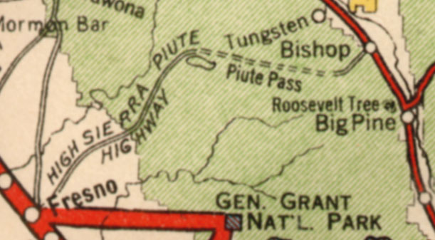
I’m in possession of an original 1927 roadway map. A small portion, shown below, shows a High Sierra–Piute Highway traversing some of the highest points in the Sierra Nevada mountains between Fresno and Bishop, California. I’ve traveled (driven, backpacked, fished, camped) much in this area. I know there are trails through Piute Pass, and the Sierra Nevada is criss-crossed by trails that were repurposed as rugged roads of some sort for a time and then were allowed to revert to trails. Maybe pioneer wagons and Model Ts drove this route through the Sierras in the 19th century and into the 1920s? That was a mystery I had to solve.
A 9-page write-up, in PDF format, presents some research into the mystery of this high-elevation trans-Sierra route. Download the write-up and retrace the steps that led to the unraveling of this mystery.
 0.7-Mb PDF, Mystery of the High Sierra–Piute Highway