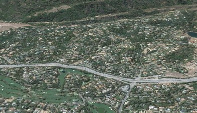
The Loma Prieta earthquake occurred on the San Andreas fault in October 1989. A few months later, in 1990, the County of Santa Clara selected a team that I worked with to prepare a report on certain anomalous phenomena in a small section of the county. In the Los Altos Hills area, shown above, ground disturbances were seen, primarily in pavements, and a cluster of damaged homes was noticed. The County and we and other researchers wondered what might account for the ground deformation, however minor, and the concentrated home damage in Los Altos Hills. The County, in particular, wishing to safeguard the local public, wanted information to guide home reconstruction and future construction in this area.
This earthquake, besides the toll it took in many lives lost and injuries and other effects, produced several other effects:
- Damage to many buildings in Santa Cruz and Watsonville, explainable by proximity of these urban areas to the epicenter.
- Damage to many structures in San Francisco and Oakland, due to liquefaction, lateral spreading, fill and other soft soil, and older construction.
- Ground disturbances in the Santa Cruz Mountains, near the epicenter, explainable by reactivation of large landslides in many cases but not all.
- Small ground disturbances in Los Gatos, located a moderate distance from the epicenter.
- Small ground disturbances and a cluster of damaged homes in the Los Altos Hills area, some 20 miles north of the epicenter.
Report for the County
¯¯¯¯¯¯¯¯¯¯¯¯¯¯¯¯¯¯¯¯¯¯¯¯¯¯¯¯¯¯¯¯¯¯¯¯¯¯¯¯¯¯¯¯¯¯¯¯¯¯¯¯¯¯¯¯¯¯¯¯¯¯
Santa Clara County tasked us with investigating the last item in the list above. The effects in Los Altos Hills, as in Los Gatos, were anomalous and needed explanation. Our report was the following:
Groffie, F.J., and Mathieson, E.L., 1990, Concentrated damage from the Loma Prieta earthquake in the Monta Vista fault study area, Santa Clara County, California: Terratech, Inc. (San Jose, California) Project 4745, prepared for Office of the Surveyor, Department of Planning and Development, County of Santa Clara, California (San Jose, California).
The County made copies available to the public for a few years and presumably used it in developing a near-term planning strategy. Presumably, the report later aided in developing revised County geologic hazard-zone maps. Presumably, it was then filed away and it has since then resided there in obscurity.
Orphaned academic paper
¯¯¯¯¯¯¯¯¯¯¯¯¯¯¯¯¯¯¯¯¯¯¯¯¯¯¯¯¯¯¯¯¯¯¯¯¯¯¯¯¯¯¯¯¯¯¯¯¯¯¯¯¯¯¯¯¯¯¯¯¯¯
In 1991, the U.S. Geological Survey took notice of our report and was interested in incorporating it into a forthcoming USGS professional paper, The Loma Prieta, California, Earthquake of October 17, 1989.
In 1992, I collaborated with a USGS geologist, Dennis Sorg, in preparing a draft paper. At some point later that year, the USGS project leaders lost interest in our work, and publications went forth without our input. Our 1992 draft paper, never published …
Sorg, D.H., and Groffie, F.J., 1992, Concentrated ground deformation and structural damage in the Monta Vista fault zone in the Los Altos Hills area, Santa Clara County: unpublished U.S. Geological Survey paper.
… is patched together here in pieces from the 1990 paper, below. The resulting amalgam is a semblance of the 1992 paper in that it presents the 1992 text, and the 1992 geologic map would have been essentially the 1990 geologic map. Unfortunately, the 26 photographs cited in the report are lost to me: presumably, they reside somewhere in a file drawer at the USGS.
The County made copies available to the public for a few years and presumably used it in developing a near-term planning strategy. Presumably, the report later aided in developing revised County geologic hazard-zone maps. Presumably, it was then filed away and it has since then resided there in obscurity.
 Text of 1992 paper, 8.2-Mb PDF
Index to mapping, 1.7-Mb PDF
Geologic map, 2.2-Mb PDF
Explanatory material for geologic map, 1.0-Mb PDF
Geologic cross section, 1.1-Mb PDF